
 Despite all the fuss and brouhaha raised over the cancellation and vague "reinstatement" of plans for a bypass recently (bypass 2.0 as we'll now call it), firm details of any alternative plan for a road through Longdendale are thin on the ground.
 But as far as we're concerned, there's no harm in speculating about what any eventual plan may look like. After locating details of alternative routes considered in past years, we can now reveal the most likely locations for any new road. And wherever it goes, it's bound to stir up new dissent, perhaps even amongst those who so far have been all for it.
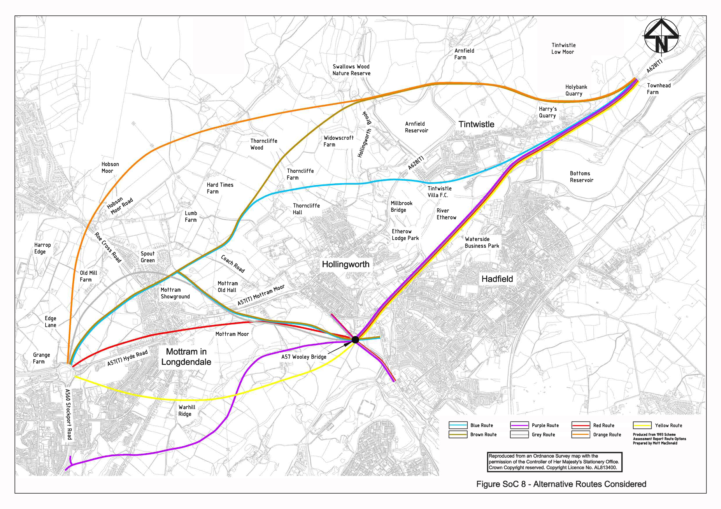
Leading up to 1993, a total of 7 possible routes had been considered by the Highways Agency as possible schemes. You can view a plan of them all here. This document* has a written description of each route, plus reasons for rejection, along with a potted history (opens PDF, see pages 27-30). The route that was eventually chosen after consultation was the eventually ill-fated (but aptly named) 'Brown Route', shortlisted alongside but winning out over the 'Grey Route'.
We feel pretty safe in speculating that any 'new' route for a bypass will utilise plans already drawn up in order to keep down costs, and the 7 routes identified in past years presumably represent all the viable options open to roadbuilders. So the question is, which one is now the most likely?
A good place to start is what has already been said in public, and in private as far as we know. As we've already pointed out, back in November 2008, local MPs and Roy Oldham met with Geoff Hoon, and the possibility of alternative alignments which "hugged the conurbations more closely" was discussed. James Purnell was said to have commented that "such a route would be popular with neither residents nor environmentalists".
However, one has to consider that the MPs wanted movement on the Bypass proposals and the PI that existed back at the end of last year: like the heady days of Globalised Capitalism, that situation no longer exists. Being left with a new situation, we imagine the MPs and local councillors are now starting to think about what costs less in terms of money, if not any supposed public support.
The only point of detail that has emerged since then has been this article written by two MEN journalists which says that the new route will be "shorter". Looking again at the route plans, to our eyes there is only really one candidate which can be considered shorter than any of the other routes - that of the 'Blue route'. The bad news for the people of Tintwistle is that this route cuts around the South side of their village, leaving them surrounded by both the existing A628 to the North and the 'new' bypass to the South. It also comes a lot closer to Hollingworth than the 'Brown route' ever threatened.
We can only surmise that Longdendale Siege members like Mike Flynn and David Moore in Hollingworth and Pat Jenner in Tintwistle will be extremely unpopular with their fellow villagers should this be the case. Rest assured, we and others will be doing our utmost to make clear to local people the implications of these plans for the area when more clarity can be obtained.
* - as we write, this document is still available on the Public Inquiry website, but we will host the file when/if the PI website is taken offline
1 comment:
I think that all routes that use the alignment of Woolley Bridge Lane (purple, grey, red, yellow) have pretty much been ruled out by development at Waterside. All these routes would now have to "kink" around the west side of the River Etherow and follow the blue route from somewhere around the Tintwistle Villa ground. It would also be difficult now to get a suitable road between the new Graphite Way roundabout and the proposed new Woolley Bridge roundabout. So I'm with you on the blue route.
Post a Comment